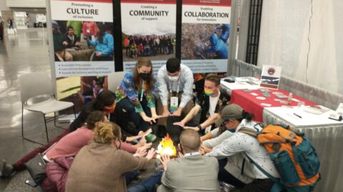
Open any geology textbook. Its full-color photographs, illustrations, graphs, and maps are valuable for providing context and learning the story that geology has to tell. For Blind and low vision learners, these images are inaccessible. Providing alternate text to describe imagery with words provides some degree of accessibility, but tactile graphics (images embossed with raised lines and textures) can enable more meaningful engagement with visual material.
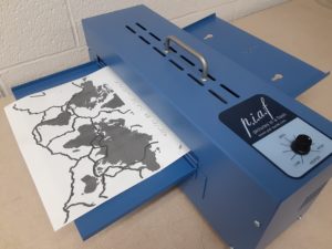
Harpo “Pictures in a Flash” (PIAF) printer with a textured world map of the tectonic plate boundaries
To support instructors in making the imagery of geology accessible to all, IAGD members Dr. Kent Ratajeski (University of Kentucky) and Jack Reed (Stanford University) have developed a digital repository of tactile images designed for high-school Earth science and college-level introductory geoscience instruction. Funding for this project was provided by a grant from the American Geophysical Union. The collection of tactile images currently includes more than 80 black-and-white vector graphics suitable for printing on heat-sensitive microcapsule paper with a Harpo “Pictures in a Flash” (PIAF) printer. The graphics are designed with principles of tactile graphic design, and annotated and labeled in Braille. Dr. Ratajeski developed the images with the consultation of Sydney Clark, a former University of Kentucky student who is blind. Clark just completed her Master’s of Public Health from Western Kentucky University and is now an epidemiologist for the state of Kentucky.
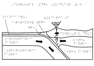
Raised-relief image of a plate subduction zone with Braille descriptions
The graphics in the IAGD tactile image repository cover a wide variety of geoscience topics, including minerals, rocks, volcanoes, the Earth’s interior, geologic structures, geologic maps and cross-sections, plate tectonics, glaciers, coasts, mass wasting, soils, geochronology, and climate change. Each graphic is tagged with metadata for discovery by search term, and is available in both PDF and PowerPoint format to allow for immediate use or customization by instructors. Geoscience instructors are encouraged to visit the new tactile image repository for more information about this great resource and to learn how to submit their own images to the collection. The tactile image repository can be accessed at https://tactileimages.theiagd.org/